|
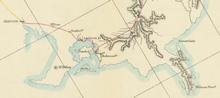
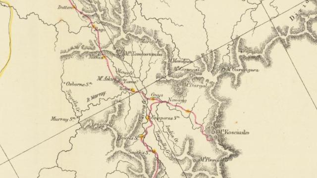
ROUTE FROM YASS PLAINS BY THE AUSTRALIAN ALPS AND GIPPS LAND TO PORT PHILLIP BY E.P. STRELESKI 1840.
Strzelecki’s map came to us from a Californian dealer who years ago obtained it from an Australian source. It’s back home in Australia now, where it belongs. It was formerly a part of Charles (Chas) Daley’s collection. Daley (1859-1947), a significant figure at the time, was a member of both the Royal Historical Society of Victoria and the Victorian Naturalist Society. He authored historical books about Victoria. We owe him a lot. It was he who had the presence of mind to publish James Macarthur’s Field Notes after he had received this manuscript in the late 1920s from Leslie McArthur, James’ son’.
Field Notes provides a detailed description of several days preceding the discovery of Mt Kosciuszko, including the historical moment when Strzelecki named it after Tadeusz Kosciuszko. It was Chas Daley who drew the scientific world’s attention to the fact that Mt Kosciuszko was named on March 12th 1840, NOT February 15th, as Strzelecki himself mistakenly informed newspapers. It’s been tough to fix this chronological error. It’s so ingrained in the minds of Strzelecki enthusiasts across the world that even today, the popular media and news portals continue to stubbornly quote the incorrect date. Amazingly (sadly), the wrong date even appears on the plastic plaque on top of Mt Kosciuszko!
The original historic 1841 map is not big (about 50 by 50 cm). It will soon find a place in a museum. Meanwhile a special copy (160 MB) is now available to be explored. We wanted it to be a gift to one and all, so we placed it today on www.kosciuszkoheritage.com. You can move up and down and enlarge any portion for study in detail. We hope it will become a precious toy for Strzelecki fans all over the world. Especially now we hear that 2023 is to be proclaimed the Strzelecki Year.
IN POLISH. Nasza organizacja Kosciuszko Heritage Inc. weszła w posiadanie oryginalnej, archiwalnej mapy sporządzonej przez Pawła Edmunda Strzeleckiego. Mapa została opublikowana w Londynie w 1841 roku, a przedstawiona jest na niej trasa tzw. południowej ekspedycji Strzeleckiego od Yass poprzez Ellerslie, Welaregang, Bringenbrong, Geehi, Mount Gibbo via malownicze Omeo poprzez gęstwiny Gippsland, dalej przez Corinellę aż do Port Phillip, czyli Melbourne. Są tam zaznaczone ręką Strzeleckiego miejsca noclegów.
Mapa przywędrowała z kalifornijskiego antykwariatu, który
kilka lat wcześniej dostał ją od kogoś z Australii. Szkoda, że nie znamy jej dziejów. Wiadomo tylko, że stanowiła ona swego czasu część kolekcji Charlesa Daleya. Charles Daley (1859-1947) to szczególna postać, znawca dziejów Wiktorii, członek Royal Historical Society of Victoria i Victorian Naturalist's Society. Jego wielką zasługą było opublikowanie (cudem odnalezionych) pamiętników Jamesa Macarthura, współorganizatora ekspedycji Strzeleckiego do Port Phillip.
W Field Notes Macarthura zawarty jest dokładny opis kilku dni poprzedzających zdobycie Góry Kościuszki i moment nadania jej imienia Tadeusza Kosciuszki. To przede wszystkim dzięki Daleyowi zwrócono uwagę na prawidłową datę odkrycia góry - 12 marca 1840. Nie było to 15 lutego, jak przez pomyłkę podał sam Strzelecki. Ta pomyłka zapuściła korzenie na całym świecie i nadal trudno ją wyplenić, bo ta niepoprawna nadal widnieje nawet na szczycie Góry Kościuszki!
Zabytkowa mapa z roku 1841 jest niezbyt duża, ma niecałe pół na pół metra. Jest już w drodze do muzeum. Na jej podstawie wykonano egzemplarz "wysoko-megabajtowy", czyli magiczną mapę, którą można dowolnie powiększać lub pomniejszać, przesuwać w dół, w górę lub na boki oglądając coraz to inne połacie kraju. Właśnie dziś jej premiera! Umieściliśmy ją na stronie www.kosciuszkoheritage.com. W ten sposób możemy naszym skarbem dzielić się z entuzjastami Strzeleckiego na całym świecie. Mamy nadzieję, że zrobi furorę już teraz, a jeszcze większą w 2023 roku, który ma być przez Sejm RP ogłoszony Rokiem Strzeleckiego.
Kliknij tutaj by postudiować mapę Strzelckiego
ROUTE FROM YASS PLAINS BY THE AUSTRALIAN ALPS AND GIPPS KAND TO PORT PHILLIP BY E.P. STRELESKI 1840. It is the rare first edition of this important map of Sir P.E. Strzelecki's explorations in the Australian Alps, which appeared in the House of Common Papers in 1841. The map illustrated the travels of Paul Edmund de Strzelecki, a seminal expedition in the history of the discovery of the interior parts of Australia and also an important chapter in the history of the first discovery of Gold on the Australian continent. The map illustrates Strzelecki's route from Sydney to Port Phillip, the road between Sydney and Port Phillip and the encampments of Strzelecki's party.
JOHN ARROWSMITH was an important English cartographer who flourished at a time of rapid British colonial expansion. A founding memeber of the Royal Geographical Society (1830), he became unofficial cartographer for the society for 43 years.He carried the title Hudrographer to Queen Victoria. He died in 1873, same year as Strzelecki.
Click here to study Strzelecki's map
|
|